The Land and the American Indians

The Indians of America, till very recent years have always had to lead their lives in accordance with their environment. The land and the climate determining their lifestyle.
On a recent tour of south west America, which several of us went on with a party from Bristol University, we went to see the rocks, but we also saw much of the Indians, present and past, and how the landscapes which we went to see, ruled their lives.
The original Indians of prehistoric times, migrated to the Southwest from the North. The Colorado plateau in Colorado, New Mexico, Utah and Arizona was occupied by these Indians for over 1300 years. They are believed to be ancestral to todays Pueblo Indians. These earliest Indians were nomadic and lived on the high plateau country, hunting, trapping, gathering nuts, seeds and fruits, and growing some corn and squashes. They have left only simple physical remains which give little information on their cultural traditions.
By A.D. 400 agriculture was becoming increasingly a central part of their economy. Permanent houses began to be built as groups became more sedentary, more numerous, and better fed. This lead to the development of distinctive cultural groups. In the places that we visited, the Anasazi (a word meaning ancient ones in the present day Navajo language) Indians used to occupy Monument Valley, the Betatakin ruins and Canyon de Chelly, and the group known as the Sinagua Indians lived in Walnut Canyon and Wupatki ruins. But around the 1300’s all these areas were abandoned completely. Many reasons have been advanced to account for this sudden desertion, drought, soil erosion, too concentrated a population, social friction, epidemics, raids by enemy nomads, but no definite cause has ever been discovered. The Navajo Indians that live in these areas at the present time, settled in them only a little over a hundred years ago.
The first substantial Indian ruins we saw were the Betatakin (meaning ‘ledge house’ in Navajo) ruins. We saw them from a trail on the canyon rim. The Betatakin Canyon has red sandstone walls rising sheer above the canyon floor to 100 metres. On the opposite canyon wall were perched the ruins, built on a steeply sloping floor of a large natural alcove, with the overhang of the canyon wall forming a sheltering roof above them. They were constructed and abandoned in two generations between 1250 and 1300 A.D. The remains represent 135 rooms, which were living quarters, granaries and a ceremonial room. It was probably once larger but has been partyl destroyewd by rock falls.
We travelled on to visit Monument Valley, which is best known nowadays as the setting for many western films. Since its first occupation by Indians, the climate has been hot and arid, much as it is today.
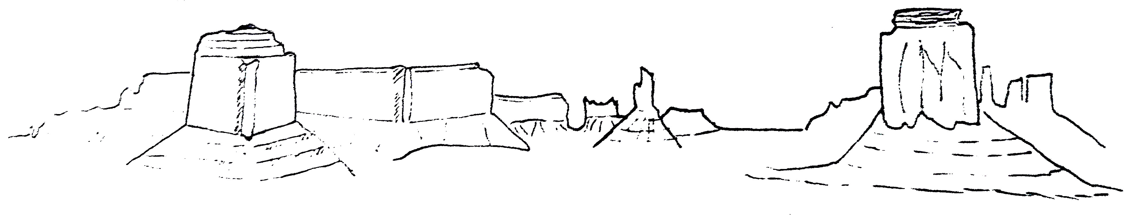
Monument Valley was more than 25 million years in the making, from rocks over 200 million years old. An upwarping of the area caused the surface to bulge and crack, allowing the forces of erosion to create the Valley we see today. The formations are capped by the harder, more resistant Triassic rocks, the Shinarump Conglomerate; the main body of them is formed from De Chelly sandstone; the base is the softer Organ Rock shale, which erodes out in horozontal terraces forming the sloping foundations of the monuments.
Monument Valley has over 100 ruins dating before 1300 A.D. As there are no perennial streams of significant volume running through the Valley, crops were planted in scattered areas to catch whatever rainfall that occurred. Crops were planted close to run off areas, and in the Seepage areas of the sandstone aquifers which never completely dry out even in drought years. Sand dunes also retain some rainwater below the surface layer of sand, so corn planted deep enough stood a good chance of survival.
This area like all the others was abandoned in the 1300’s. Nowadays the Navajo’s grow small quantities of crops and herd sheep and livestock in the area.
We visited canyon deChelly which has been inhabited by Indians since the earliest times. The Canyon is formed in the reddish sandstone of the Permian age, layed down more than 200 million years ago. The streams of this region flow during the rainy season and during the spring run off of the mountain snows. The soils of the canyon base are very fertile with a year round water supply, even in the driest months, water is available just below the ground surface.
The ruins visible there were built between 350 and 1300 A.D. The earliest houses were pit houses, which had their lower portion sunk into the ground. These were built on the canyon floor, and their inhabitants grew maise and squash and made baskets and woven articles. It was later than they learnt to make pottery, grow cotton and had bows and arrows, and started living in villages of rectangular stone houses, built on the canyon walls in recesses, often in apparently inaccessible spots.
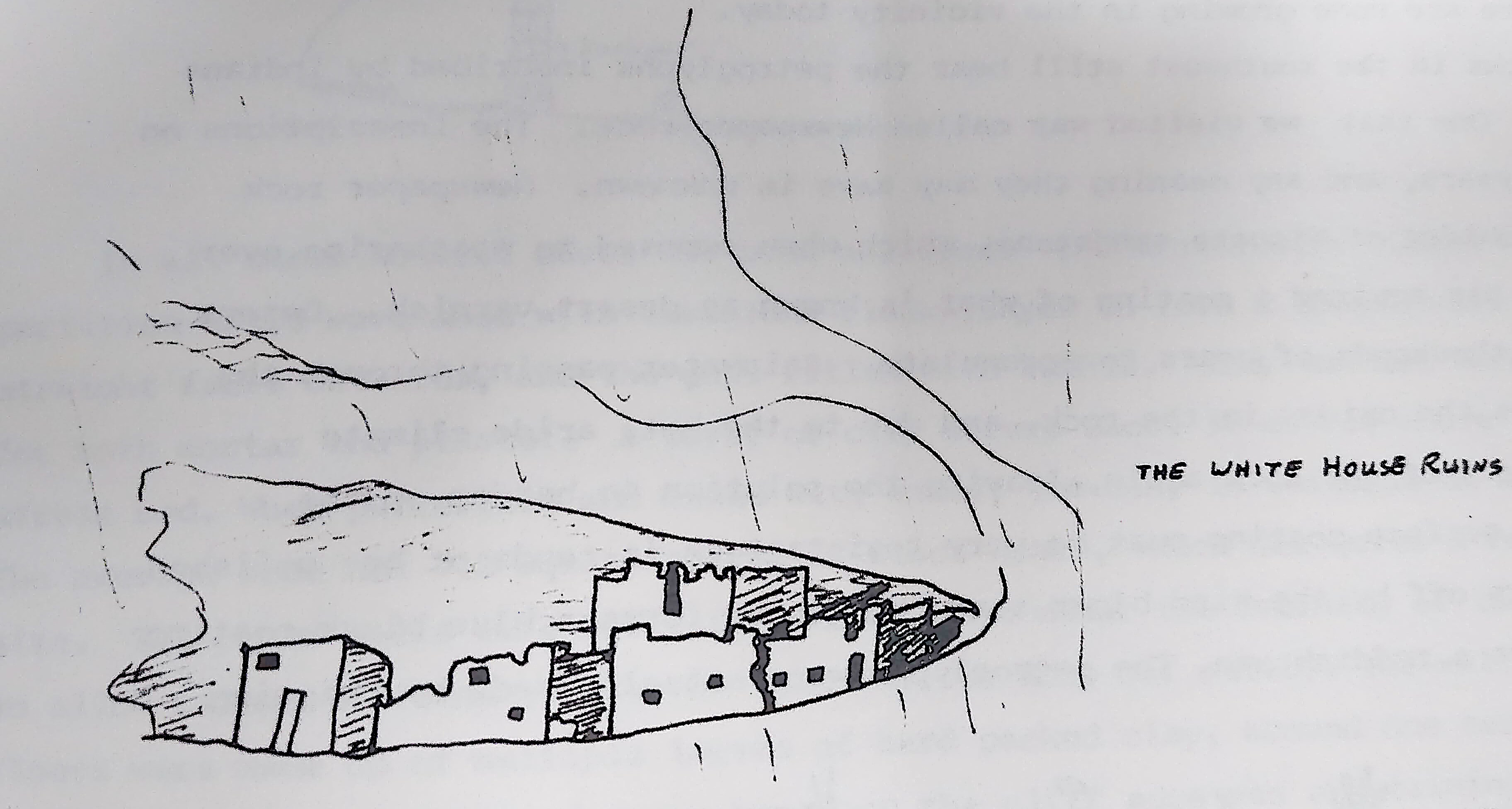
The reasons for this may have been to avoid the flash floods of the canyon floor, protection against attack from other tribes or wild animals or the general protection against the weather afforded by the canyon walls. One of the ruins known as the White house ruin still remains relatively secure up on the canyon wall, but another Slide Rock, as the name suggests, displays vividly the problem of building on such a site. Most of the buildings have slipped off the ledge, and lie as rubble at the foot of the canyon wall.
Wupatki, in the Sunset Crater area, was the next ruin we visited. About 600 A.D. a few Indians were living in the area in pit houses (which were very efficent forms of dwelling for keeping out the summer heat and the winter cold) and farming the area. Due to the arid nature of the soil, crops were grown around the edge of the old cinder fields for the best yield. Then a volcanic eruption covered their homes and drove out the people. But the fine black volcanic ash, which spread over an area of 800 square miles formed a porous layer over the soil, and trapped the moisture, producing a new area of productive farmland into which many Indians moved back from the surrounding districts. Villages were established throughout the area. Wupatki was one of the largest of these. By the 1100’s it was a multiple dwelling of more than 100 rooms and in places four stories high. It is believed to have house 250-300 inhabitants. Beside the ruin protected from the prevailing winds is an open air amphitheatre. All these buildings were built from the local Moenkopi sandstone. This rock breaks down into good building stones. The banded layers of sandstone, developed as silt in an ancient shallow sea, split along horozontal planes and so was easily quarried and used as building stone by the Indians. Timbers were also used in the buildings as beams, door lintels etc. The timber used was Ponderosa Pine, although there are none growing in the vicinity today.
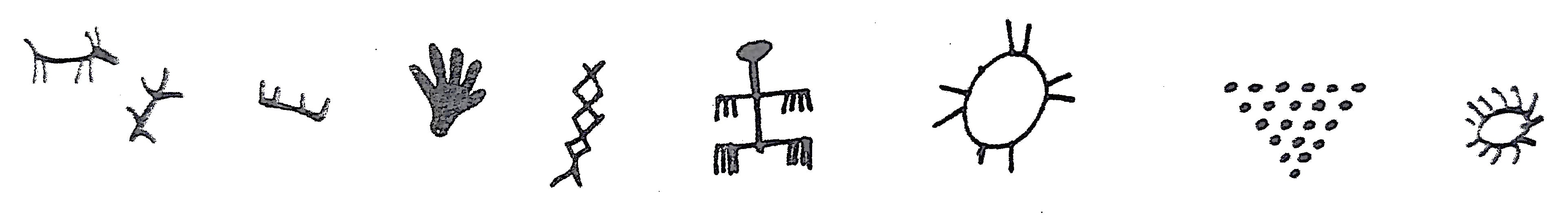
Many rocks in the southwest still bear the petroglyphs inscribed by Indians in the past. One that we visited was called Newspaper rock. The inscriptions on it span 1000 years, and any maning they may have is unknown. Newspaper rock itself is a boulder of Wingate sandstone, which when exposed to weathering over the centuries has acquired a coating of what is known as desert varnish. Desert varnish takes thousands of years to accumulate. Rainwater passing through the rocks dissolves the oxides in the rock, and due to the hot, aride climate is evaporated out of the rock again, leaving the solution to harden on the surface. This surface coating must be very resistant as it tends to be polished rather than worn off by the wind blown sand. Manganese forms a blue black coating while iron forms a reddish one. The petroglyphs were actually made by chipping off the desert varnish to allow the pale cream colour of the sandstone to show through the dark coating.
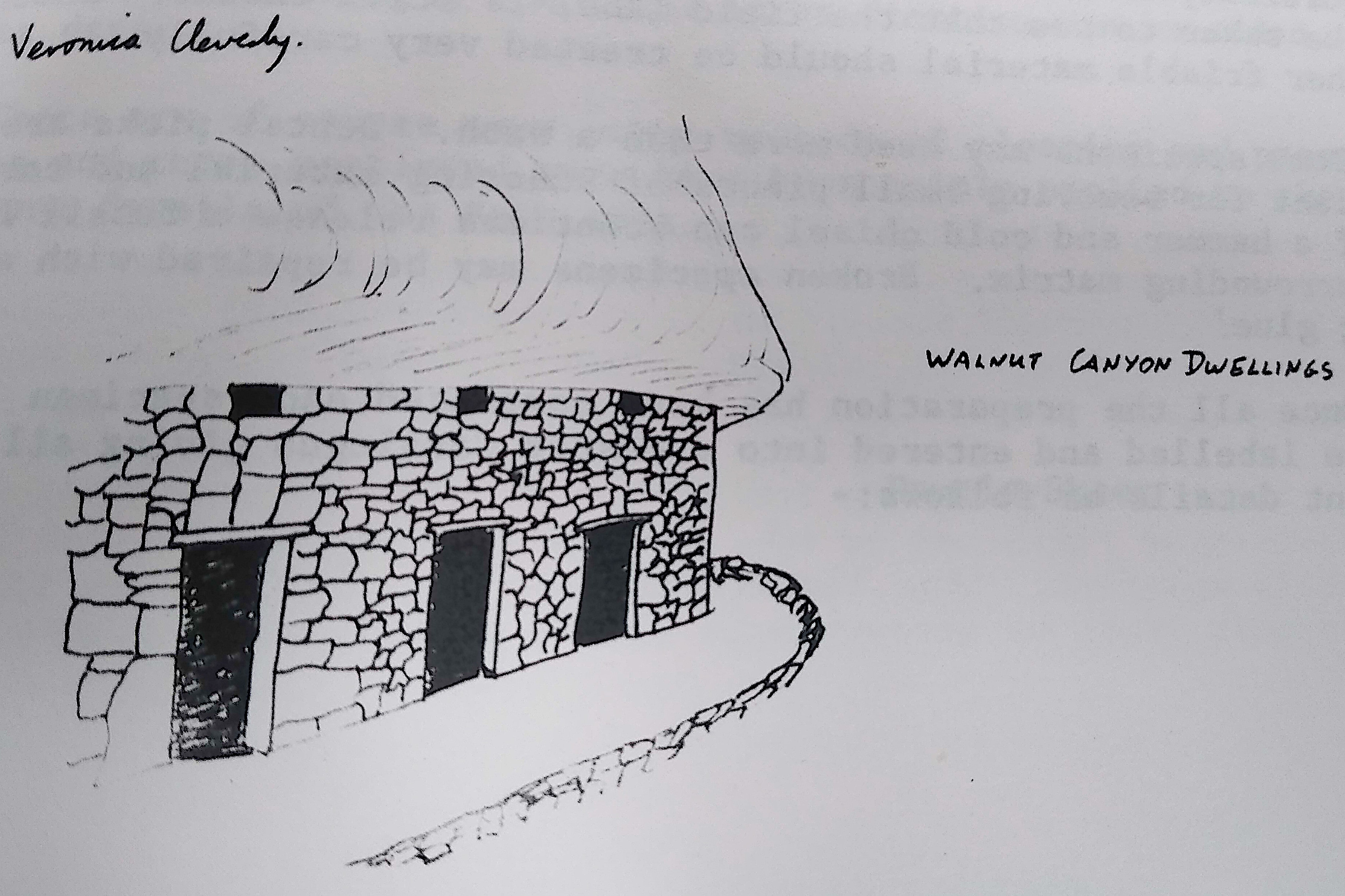
Walnut Canyon was the only place we visited where we were able to go inside restored Indian cliff dwellings. The Canyon walls are formed at the base from petrified sand dunes of the Toroweap formation, 200 million years old. Above this are the stair like ledges of the Kaibab limestone, formed from compressed fine silts and shells. The uplift of the land caused Walnut Creek to cut down and form the canyon. It cut into the soft limestones. The harder sandstone caused a narrowing of the canyon at the base. Ledges were formed in the softer limestone by the erosive forces of wind, water and ice. It is these ledges that form the basis for the Indian dwellings.
The Canyon today is 122metres deep. A stream, probably 1.2-1.5 metres deep flowed in Walmut Canyon when the Indians came. The present remains date from around 1120-1250 A.D., and accomodated a maximum population of 400-500 people. The main canyon could be entered from side canyons which emerge nearly on the level where most of the cliff dwellings are situated, so trails could be built to gain access to water, firewood and farming fields. Earthwuake fault lines also provide ways to get to and from the rim or the base of the canyon.
Walking along in front of the dwellings was quite cool in the wind, but on stepping inside any of them, I was immediately struck by the warmth inside. Obviously they trapped the warmth of the sun which had been on them during the day.
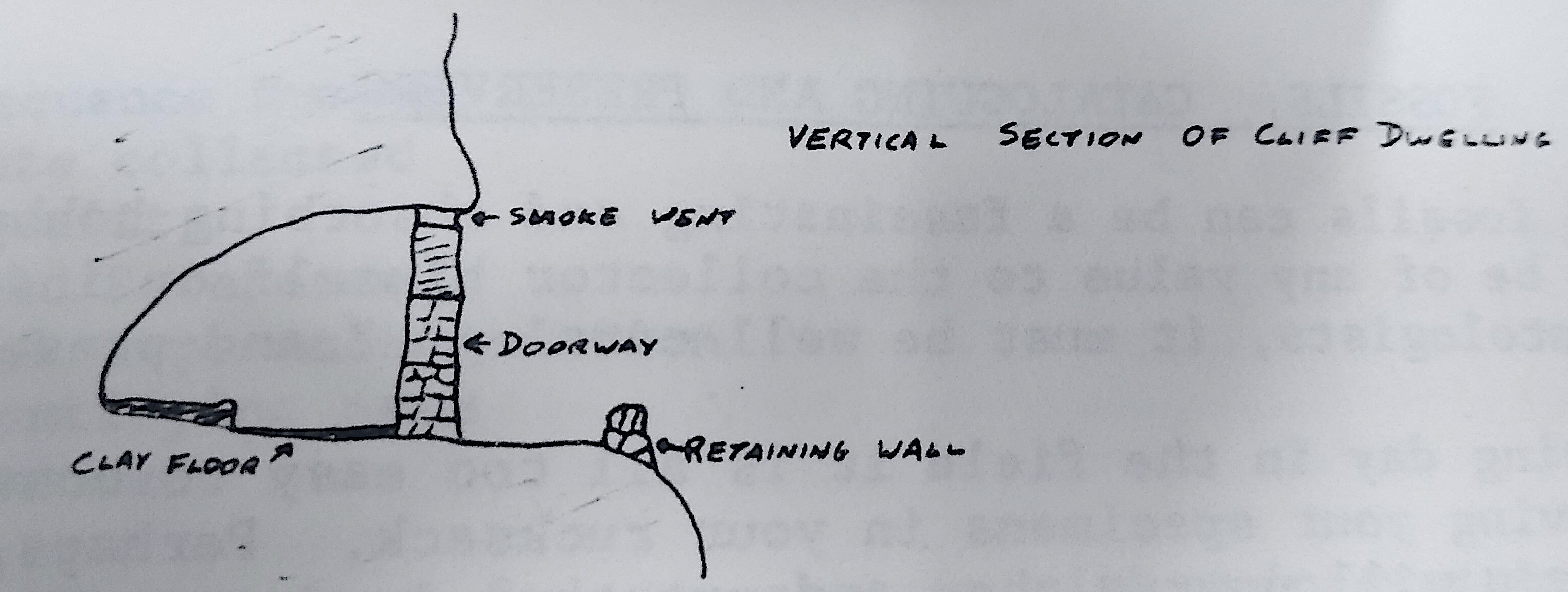
In all cases natural caves had been utilised. The fronts were closed and partition walls were made with limestone blocks, layed to form a double wall with straight faces outwards, and the gaps filled with rubble. Clay and mud were used for both mortar and plaster. A layer of clay occurs about 30 metres above the stream bed. When pulverized and mixed with water, the clay is suitable as mortar. The average room has 7.2 square metres of floor space, which was quite a reasonable size. The outer walls were built far enough back under the overhang of the rock to allow rainwater running down the rock face to drip off outside the wall. The floors were made up of multiple layers of hard packed clay, around one centimetre thick in total. In front of every house on the cliff edge was a retaining wall, enclosing the open air work area. Very little wood was used in their construction, only for things like door lintels.
Farming was difficult in this area, they grew beans, squash and corn whereever the soil was deep enough around the canyon rim, relying solely on rainfall and losing their crops in years of drought. They also made extensive use of the wild plants around them, e.g. Blue Yucca plants which are quite common in the area, they used for rope making, matting, baskets, bags, sandals and nets. They also ate the seeds and fruits.
The insight into the lives past and present, showed how people adapted to live with the land, as opposed to adapting the land to fit the people. It was a much harder way of life, but it has left the land much as it was when they found it.