The Central Brecon Beacons
The northern margin of the South Wales basin is marked by a series of outcrops, the more resistant rocks forming distinct escarpments each dipping gently southwards. Craig-y-Llyn (1969 ft) marks the highest point on the Pennant Sandstone scarp of Coal Measure age, while to the north is the escarpment of the Carboniferous limestone with its sheer cliffs, bare rock pavements, joints and its under-ground cave systems. These give way northwards to the high, almost unbroken escarpment of the Brecon Beacons, culminating in the highest point in South Wales, Pen-y-Fan (2906 ft/886m) and composed of red and purplish beds of the Old Red Sandstone facies of the Devonian Period. These in turn overly the older marine beds of the Silurian Period exposed in the Senni valley to the north.
During the Silurian Period, the area which is now southern Powys, was covered by a shallow sea on the edge of a large continental plate which was slowly moving towards a second continental plate approaching from the north-west. Towards the end of the Silurian Period these plates slowly collided causing compression, folding and uplift and the creation of the high, arid landmass known as St. George’s Land. The Old Red Sandstone beds of the Brecon Beacons are composed of conglomerates, sandstones and marls, sediments derived from the land to the north and deposited by rivers, in deltas and in lagoons along coastal plains to the shores of a large bay bordering the Devonian Sea lying on the south. The duration of the Devonian Period here was some 50 million years, from 395 to 345 million years ago.
The Lower Old Red Sandstone of the Brecon Beacons forms a series of at the base of the series and consists of a mixture of conglomerates and 2000 feet of the Lower Red Marls of the Downtonian have transgressed the Silurian marls of the brown bands with marine fossils. The junction between the Silurian and the Devonian Periods is now generally taken to lie in the Red Marls. These Downtonian beds show cyclic deposition with fining upwards, conglomerates are followed by sandstones and then marls. The conglomerates frequently lie on eroded surfaces and rain-pitting and sun cracks are to be seen. There are armoured platy remains and parts such as plates of early jawless, armoured ‘fishes’ – the ostracoderms such as cephalaspids and pteraspids.
Figure 1
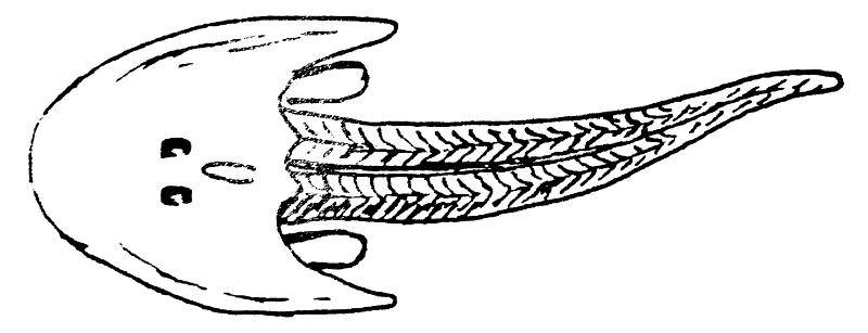 Cephalaspis
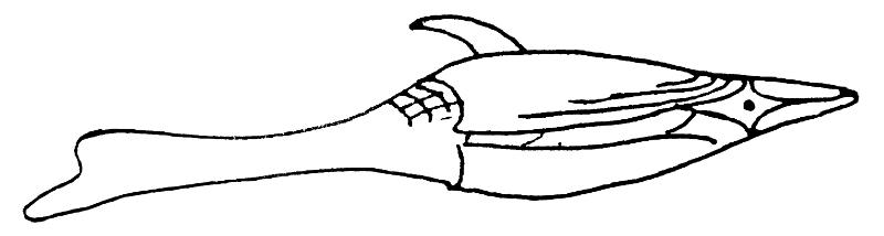 Pteraspis
These Red Marls are succeeded by thick sandstones of the Brecon series, 2000 feet – 3000 feet in all. The lower 1000 feet, the Senni Beds consist of red sandstones, many micaceous and with inter-bedded green chloritic bands. This is one of the most important horizons in the World for Devonian plants, the first vascular plants. The Senni Beds are succeeded by the Brownstones, 1500 feet of red and purple sandstones showing evidence of cross-bedding and channel development but containing no fossils.
There are no beds of Middle Old Red Sandstone age in the Central Brecon Beacons, indicating a period of disruption. The Upper Old Red Sandstone lies unconformably on the Brownstones and contains nice beds of quartzites and conglomerates of the plateau beds. These 100 feet of higher summits and give them their characteristic table-top form e.g. Pen-y-Fan and Corn Du. An excellent view may be obtained from the Brecon Beacons Mountain Centre near Libanus.
Craigs-y-Fro. This small quarry lies to the north-west of the alopes of Pen-y-Fan in the Tarell Valley and on the west side of the A470 road. It is cut in the Senni beds and has green and red sandstones and siltstones with occasional shaley bands dipping south-eastwards at an angle of 5°. There is a level of conglomerate and ripple marks indicating deposition in a braided river environment. The site has become famous as a locality rich in some of the earliest vascular plants and was that used by Sir. David Attenborough in his recent television series. The plant remains were washed from the land surface to the north, and show for the first time simple water-conducting systems and were spore bearing e.g. Cooksonia, Gosslingmia, Zosterophyllum and Dawsonites. The harried simple stems sometimes branch and have at their tips or massed laterally, sporangia frequently club-shaped. Drepanophycus has been found here in the Senni beds and shows the earliest example of a leaf. In Wales, some specimens are preserved in iron pyrites. The green colour of some of the beds may be due to the presence of the plant material which maintained reducing conditions.
Figure 2
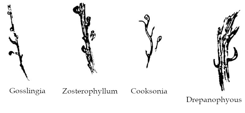
(After Basset and Edwards) x2
Northwards, older beds of the Downtonian Red Marls are exposed in the lower Tarell and Senni valleys. These Upper Silurian beds are well seen in the disused quarry (not at the time available) of Capel Sorel, west of Sennybridge in the upper Usk valley. Ludlovian mudstones are exposed in a roadside cutting just east of Halfway and within a mile, these are very fossiliferous and contain brachiopods such as Dayia navicula and Camarotoechia. A quarry at Halfway in Wenlock mudstones yields a rich fauna occurring in bands of e.g. Atrypa reticularis, Camarotoechia borealis, Eospirifer plicatella and the trilobite Calymene. These marine fossils indicate the shallow sea conditions existing prior to the deposition of the Old Red Sandstone rocks.
The scenery of the Brecon Beacons is due not only to the varied rocks and their movements but also to the modifying effect of the ‘Ice age’.
Figure 3: Rock succession in the Brecon Beacons
![]()
Figure 4: Diagrammatic horizontal section through the rocks of the Brecon Beacons
![]()
During the Pleistocene Period - from approximately 2 million years to 10,000 years ago, the land was affected by the accumulation of glacial ice and also by the periglacial conditions at the end of the Pleistocene. The southen slopes have long, over-deepened valleys such as that of the Nant Crew and the Taff, some today containing reservoirs, whereas the north facing slopes are notched by quite spectacular, steep-sided corries which were gouged out by ice. Some of these corries contain lakes occupying small basins and dammed by morainic barriers e.g. Llyn Cwm Llwch beneath the northern slopes of Corn Du. However it is now considered that some of the corries can be at least partly attributed to the effect of rotational landslip aided by lubrication under peri-glacial conditions e.g. Cwm Cerrig Gleisiad. Glacial moraine and drift together with large quantities of head deposits floor the valleys into which the modern stream pattern is deeply incised. Thick deposits of head - ill-sorted solifluction clays and gravels have built up terraces on valley sides such as Glyn Tarell. Lying to the north-east of Brecon is Llangorse Lake (Llyn Syfadden) the largest natural lake in South Wales which occupies a rock basin scoured by ice and surrounded by barriers of drift.
Map References.
Pen-y-Fan ……………………. 016214
Craigs-y-Fro ………………… 971208
Llyn Gwyn Tlwch ……………… 995225
Cwm Cerrig Gleisiad ………….. 977253
Capel Horeb …………………. 845324
Halfway …………………….. 828328
Llangorse Lake ………………. 117261
Brecon Beacons Mountain Centre … 977262
Figure 5.
![]()